 Images on this page
Project Title
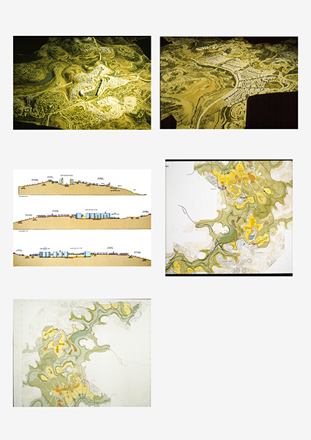
West Jerusalem Master Plan
Description
Sponsored by the Israel Land Authority and the Municipality of Jerusalem, this three-dimensional urban design plan incorporates areas that have been annexed to Jerusalem toward the west, anticipating the need for growth and the expansion of the city’s Jewish population. The plan aims to increase available housing in the capital, create more opportunity for equitable housing prices, and slow migration from the city.
Covering an area of 5500 acres and planning for the gradual construction 20,000 units of residential housing, the master plan embodies one of the largest planning initiatives undertaken in Israel. The master plan extends from Ramot in the north, through Mevaseret Zion, and southward, including Har Haret, to the Rephain Valley. At the time the plan was initiated, a number of roads had been projected in the area. Under the auspices of the plan, three-dimensional models at the scale of 1:2500 were built to evaluate the roads. The proposed roads were found to be extremely damaging to the landscape and the topography, and they were expected to provide poor service to the areas most likely to be enveloped. As a result, over the next five years the roads’ design was totally reworked.
The plans were adopted by the sponsors and are currently being revised for approval by the District Planning Commission.
Images on this page: 1 Aerial view of physical model; 2 Aerial view of physical model; 3 Site sections; 4 Site plan; 5 Site plan
Jerusalem, Israel
Timeline
between 1996 and 2007
Location
Status
Completion Date
Notes
Client: Israel Land Authority
Project Type
Creator
Safdie Architects
Rights:
© Safdie Architects. Explicit permission to use images is required. Contact the communications department at Safdie Architects (media@safdiearchitects.com) for more information.